
SightNav your trusted partner in new technology consulting
We're a team of experts fueled by a passion for emerging technologies – drones (air, land, sea), advanced image processing, secure communication, radio signal systems (jamming and anti-jamming) and cybersecurity
SightNav your trusted partner in new technology consulting
We're a team of experts fueled by a passion for emerging technologies – drones (air, land, sea), advanced image processing, secure communication, radio signal systems (jamming and anti-jamming) and cybersecurity
Our partners
A leader in utility solutions, driving reliability, resilience, and efficiency within delivering an integrated approach to border security and migration.
Reduce project timelines by up to 30%.
Our precise 3D models and progress monitoring streamline workflows, identify bottlenecks early, and enhance collaboration for faster project completion.
Boost efficiency and accuracy
Replace traditional ground survey methods with fast and cost-effective aerial mapping, ensuring precise measurements and detailed terrain analysis.
Improve infrastructure management.
Our current orthomaps and 3D city models provide a reliable data foundation for informed planning, asset maintenance, and optimized resource allocation.
SightNav transforms aerial and satellite imagery into actionable insights. Our advanced photogrammetry and 3D modelling deliver unparalleled precision and detail. Empower your industry with data-driven decision-making and optimized operations.
Elevate Projects Across Industries
SightNav provides tailored aerial surveying and 3D modeling solutions for sectors ranging from construction and engineering to urban planning and beyond.
3D Modeling of Terrain and Construction Sites
Create an ultra-realistic digital twin of your construction site for meticulous planning, improved project safety, and streamlined execution.
Progress Monitoring with Aerial and Satellite Imagery
Track your project's evolution from above, proactively identify potential delays, and maintain full control over timelines and budgets.
3D Modeling using Aerial and Satellite Imagery
Transform aerial and satellite imagery into detailed 3D models, unlocking their potential for surveying, engineering analysis, and immersive visualization.
What we do?

Cyber security solutions
Adhering to stringent industry regulations, ensuring that our practices meet global security benchmarks
Encrypted communication systems
Safeguarding your information during transmission and storage.

Data-Driven Insights
Leverage detailed models for analysis, enhancing decision-making in construction, environmental studies, and more.
Continuous Monitoring
Proactively detecting and neutralizing threats to maintain system integrity.
Innovative Modelling
We use the power of advanced 3D texture models to visualize environments with unmatched realism.
Diverse Applications
From urban planning and architecture to entertainment and virtual reality, our models provide the foundation for innovation.
Radiocelctronic solutions
Jamming, anti-jamming and spoofing
Drone navigation
AI support systems, Geonavigation, last mile targeting
Ready to transform your Projects?
Get in touch with SightNav and discover how our cutting-edge solutions can optimize your operations and drive innovation.
Driving Innovation & Impact
Read in-depth case studies that highlight the challenges, solutions, and transformative results achieved by our clients.
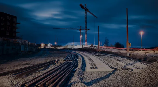
Revolutionizing Rail Infrastructure Monitoring with PKP PLK
Drone-powered data capture and analytics platform empowered PKP PLK to optimize project timelines, streamline workflows, and achieve significant cost savings while enhancing project transparency.
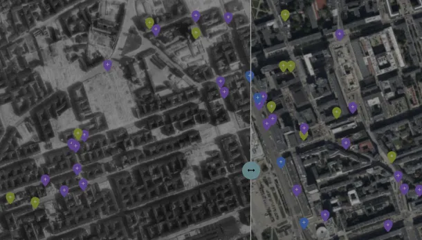
Transforming History with Cutting-Edge 3D Mapping
SightNav Team collaborated with the Warsaw Uprising Museum to meticulously map historic landmarks, revolutionizing how visitors engage with history and supporting the preservation of cultural heritage.